Death Valley is a desert valley located in Eastern California. Situated within the Mojave Desert, it features the lowest, driest, and hottest locations in North America. Badwater, a basin located in Death Valley, is the specific location (36° 15′ N 116° 49.5′ W) of the lowest elevation in North America at 282 feet (86.0 m) below sea level. This point is only 84.6 miles (136.2 km) ESE of Mount Whitney, the highest point in the contiguous United States with an elevation of 14,505 feet (4,421 m). Death Valley holds the record for the highest reliably reported temperature in the Western hemisphere, 134 °F (56.7 °C) at Furnace Creek on July 10, 1913—just short of the world record, 136 °F (57.8 °C) in Al ‘Aziziyah, Libya, on September 13, 1922.
Located near the border of California and Nevada, in the Great Basin, east of the Sierra Nevada mountains, Death Valley constitutes much of Death Valley National Park and is the principal feature of the Mojave and Colorado Deserts Biosphere Reserve. It is located mostly in Inyo County, California. It runs from north to south between the Amargosa Range on the east and the Panamint Range on the west; the Sylvania Mountains and the Owlshead Mountains form its northern and southern boundaries, respectively. It has an area of about 3,000 sq mi (7,800 km2). Death Valley shares many characteristics with other places below sea level.
Geology
Death Valley is one of the best geological examples of a basin and range configuration. It lies at the southern end of a geological trough known as Walker Lane, which runs north into Oregon. The valley is bisected by a right lateral strike slip fault system, represented by the Death Valley Fault and the Furnace Creek Fault. The eastern end of the left lateral Garlock Fault intersects the Death Valley Fault. Furnace Creek and the Amargosa River flow through the valley but eventually disappear into the sands of the valley floor.
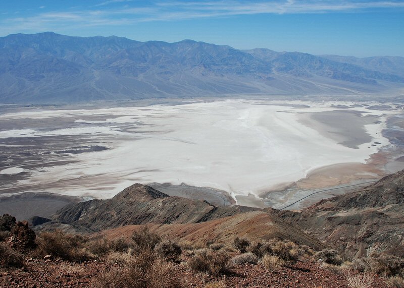
Death Valley also contains salt pans. According to current geological consensus, during the middle of the Pleistocene era there was a succession of inland seas (collectively referred to as Lake Manly) located where Death Valley is today. As the area turned to desert the water evaporated, leaving behind the abundance of evaporitic salts such as common sodium salts and borax, which were subsequently exploited during the modern history of the region, primarily 1883 to 1907.
As a general rule, lower altitudes tend to have higher temperatures where the sun heats the ground and that heat is then radiated upward, but as the air begins to rise it is trapped by the surrounding elevation and the weight of the air (essentially the atmospheric pressure) above it. The atmospheric pressure is higher at very low altitudes than it is under the same conditions at sea level because there is more air (more distance) between the ground and the top of the atmosphere. This pressure traps the heat near the ground, and also creates wind currents that circulate very hot air, thereby distributing the heat to all areas, regardless of shade and other factors.
This process is especially important in Death Valley as it provides its specific climate and geography. The valley is surrounded by mountains, while its surface is mostly flat and devoid of plants, and of which a high percentage of the sun’s heat is able to reach the ground, absorbed by soil and rock. When air at ground level is heated, it begins to rise, moving up past steep high mountain ranges, which then cools slightly, sinking back down towards the valley more compressed. This air is then reheated by the sun to a higher temperature, moving up the mountain again, whereby the air moves up and down in a circular motion in cycles, similar to how a convection oven works, albeit a natural one. This superheated air increases ground temperature markedly, forming the hot wind currents that are trapped by atmospheric pressure and mountains, thus stays mostly within the valley. Such hot wind currents contribute to perpetual drought-like conditions in Death Valley and prevent much cloud formation to pass through the confines of the valley, where precipitation is often in the form of a virga (rain that evaporates in mid-air before hitting the ground). Death Valley holds temperature records because it has an unusually high number of factors that lead to high atmospheric temperatures.
Climate
The depth and shape of Death Valley influence its summer temperatures. The valley is a long, narrow basin 282 feet (86 m) below sea level, yet is walled by high, steep mountain ranges. The clear, dry air and sparse plant cover allow sunlight to heat the desert surface. Summer nights provide little relief as overnight lows may only dip into the 86 to 95 °F (30 to 35 °C) range. Moving masses of super-heated air blow through the valley creating extremely high temperatures.
The hottest air temperature ever recorded in Death Valley (Furnace Creek) was 134 °F (57 °C) on July 10, 1913, at Furnace Creek. During the heat wave that peaked with that record, five consecutive days reached 129 °F (54 °C) or above. The greatest number of consecutive days with a maximum temperature of 100 °F (38 °C) or above was 154 days in the summer of 2001. The summer of 1996 had 40 days over 120 °F (49 °C), and 105 days over 110 °F (43 °C). The summer of 1917 had 52 days where temperatures reached 120 °F (49 °C) or above with 43 of them consecutive. Four major mountain ranges lie between Death Valley and the ocean, each one adding to an increasingly drier rainshadow effect, and in 1929 and 1953 no rain was recorded for the whole year. The period from 1931 to 1934 was the driest stretch on record with only 0.64 inches (16 mm) of rain over a 40-month period.
From 1961-2008 the weather station at Death Valley (Furnace Creek) recorded an average yearly temperature of 76.7 °F (24.8 °C) with an average high in January of around 66 °F (19 °C) and 116 °F (47 °C) in July. From 1934-1961 the weather station at Cow Creek recorded a Mean Annual Temperature of 77.2 °F (25.1 °C)°F.
The period from July 17–19, 1959 was the longest string of consecutive days where nighttime low temperatures did not drop below 100 °F (38 °C). The highest ever night time low temperature in Death Valley was 103 °F (39 °C) recorded on July 5, 1970 and July 24, 2003.
The longest stretch of consecutive days where temperatures reached 90 °F (32 °C) or more was 205 during Apr-Oct 1992. On average there are 192 days per year in Death Valley where temperatures reach 90°F (32°C) or more.
The lowest temperature recorded at Greenland Ranch was 15 °F (−9 °C) in January 1913.
The average annual precipitation in Death Valley (Greenland Ranch Station) is 1.58 inches (40 mm). The wettest month on record is January 1995 when 2.59 inches (66 mm) fell on Death Valley.[18] The wettest period on record was mid 2004 to mid 2005, in which nearly 6 inches (150 mm) of rain fell in total, leading to ephemeral lakes in the valley and the region and tremendous wildflower blooms. Snow with accumulation has only been recorded in January 1922, while scattered flakes have been recorded in other occasions.
In 2005, Death Valley received four times its average annual rainfall of 1.5 inches (38 mm). As it has done before for hundreds of years, the lowest spot in the valley filled with a wide, shallow lake, but the extreme heat and aridity immediately began sucking the ephemeral lake dry.
In 2005, a big pool of greenish water stretched most of the way across the valley floor. By May 2005 the valley floor had resumed its more familiar role as Badwater Basin, a salt-coated salt flats. In time, this freshly dissolved and recrystallized salt will darken.
The western margin of Death Valley is traced by alluvial fans. During flash floods, rainfall from the steep mountains to the west pours through narrow canyons, picking up everything from fine clay to large rocks. When these torrents reach the mouths of the canyons, they widen and slow, branching out into braided streams. The paler the fans, the younger they are.
During the Pleistocene ice age, which ended roughly 10,000–12,000 years ago, the Sierra Nevada ranges were much wetter. During that time, Death Valley was filled with a huge lake, called Glacial Lake Manly, that was nearly 100 miles long and 600 feet deep.[23] Remnants of this wetter period can still be seen in the region today, including the presence of several isolated populations of pupfish that still call the region home.
As one would imagine, the humidity levels in Death Valley are generally low, and during the summer, the relative humidity can remain below 30% for weeks at a time. This coupled with the high air and surface temperatures and windy conditions rapidly evaporates any standing fresh water. From standard evaporation pans, the typical summer daily evaporation is determined to be 0.75 inches/day (1.9 cm/day) from May through August with maximum rates at 1.50 inches/day (3.8 cm/day) during the summer. Over the long term (1961-2002), the annual total potential evaporation is 143 inches per year (363 cm/yr). This rate of moisture loss greatly exceeds the average annual precipitation of 1.9–2.2 inches (4.8–5.6 cm) per annum, making the region arid. Standing water and damp mud, however, can exist on the surface on the salt flats in Death Valley because evaporation is hindered by high salt content of the water.
Wind also plays a significant role in the dryness of Death Valley since it is a major component in evaporation. While there have been no long-term direct measurements of wind speed, the climate record does include daily wind movement data. This measure determines the wind movement per day by counting the total distance of wind moving past the anemometer during the measurement period. (Each rotation of the anemometer corresponds to a given “distance” of wind movement, and the meter’s counter clicks off the distance of “wind travel” in much the same way our car odometer counts miles travelled.) Average daily wind movement at Death Valley is lowest during the winter and peaks in early spring. From March to May the average daily wind movement is 250 to 300 miles (200-480 km) per day. Dividing that number by 24 hours gives a rough estimate of average daily wind speed: 10-4 to 12.5 mph.
Solar heating of dark, sparsely vegetated surfaces by radiation through clear, dry air. Since the vegetation cover is sparse, little solar radiation is used for evapotranspiration and instead heats the ground and surface air.
Meteorologists know that the hottest days usually occur in Death Valley when a high pressure ridge centers over western Nevada. The ridge thus blocks cooler maritime air from pushing east while a thermal low located in southern California directs hot air from the deserts of southern Arizona and Mexico into the valley.
The highest ground temperature ever recorded was 201oF (93.9oC) on 15 July 1972. The air temperature at standard thermometer height that day peaked at 128oF (53.3 oC). The hottest month ever was July 1917 averaging 107.2oF (41.8oC); the second hottest, and the hottest of modern record, was July 2005 averaging 106.5oF (41.4 oC).
The coldest month on record was December 1990 at 44.9oF (7.2 oC). The coldest recorded daily temperature was 15oF (-9.4oC) on 18 January 1913 (the same year as the record high). During the winter 1928/29, 72 consecutive days recorded temperatures at or below freezing. The lowest summer temperature since 1961 is 54oF (12.2oC) on 6 June 1996.
The wettest calendar year in Death Valley climate history was 1941 which saw 4.63 inches (118 mm) accumulate. The most precipitation over a 12-month period fell between 1 October 1977 and 30 September 1978: 6.40 inches (162 mm). Second was the period July 1977 to June 1978: 5.09 inches (129 mm). The wettest month was January 1995 when 2.59 inches (66 mm) accumulated. The wettest day was 15 April 1988 when 1.47 inches of rain fell. The only other day on record to exceed an inch of rain was 26 September 1997.
Death Valley precipitation records include calendar years with no precipitation: 1929 and 1953. A string of 40 months from 1 March 1931 to 30 June 1934, recorded a total of only 0.64 inches (16 mm).
From Wikipedia, the free encyclopedia